For the past 100 days, I have visited shale formations with oil and gas from Amarillo in the north to Laredo and Eagle Ford in the south, from Odessa and the Permian Basin in the west to Nacogdoches and the Haynesville Shale in the east. The only remaining shale formation to visit on my list was the Barnett Shale around Fort Worth West of Dallas. It was here that the US adventure with fracking began and in September 2013 RRC, Railroad Commission of Texas reported that one had drilled 18,300 wells in the Barnett Shale.


In last May 2011 the USA’s governmental energy authority, the EIA, presented a map of 15,856 wells in Barnett Shale, the Fort Worth Basin (above) – i.e. 2,444 less than today. Red represents horizontal gas wells, orange represents vertical gas wells, violet represents horizontal oil wells, and finally green represents vertical oil wells. From the map, we see that Fort Worth is surrounded by fracked wells and that some are even sited within the city.
If one studies the possibilities for fracking in Europe, there are many who assert that the so-called Paris Basin is the one with the greatest potential. I have difficulty imagining that the French are willing to have 18,000 wells drilled in central Paris and its surrounds. It is an issue how these wells would affect the physical environment around Paris. To see more of the reality of fracking activity around Fort Worth we chose to drive on smaller roads and with Google Map, we could find satellite images and see where drilled wells are. We traveled down Interstate W35 to Fort Worth and then on a little road south of Fort Worth, 1187 – Crowley Plover Road. With the help of Google’s satellite images, we could confirm that fracking activities existed along this road.


Our first stop showed the difference between shale oil and shale gas. In the place of the “nodding donkey” oil pumps, we saw compressors that help to suck out gas from the field at the same time as it is prepared to be sent farther afield in the national natural gas net. The first gate that we stopped at (see above) showed that the area had ten wells and the gas installation was the one in the picture.


Google shows that similar installations (the three squares in the top left of the image above) can lie in immediate juxtaposition to residential areas, but we also saw them along the road where the large ranches exist. In the USA it is the private landowner that owns the gas and oil beneath a property. Thus, for the owners of ranches, each gas well is a source of income. Certainly, they would look upon this activity differently if it was the state that owned the gas. If the drill is done in a residential area such as that above, then the owners of those properties should also receive income from the activity, but how income is distributed in reality, I do not know. For the area around Paris it is the French government that owns the gas, and so there would certainly be massive protests from property owners if drilling occurred near their houses.

Road 1187 comes to HW377 that then leads directly into Fort Worth. On the right of HW377 and up to the sea there is a fracking area where one can drive in and look a little more closely.


The installation that we saw was joint for six wells, and on the other side of the road there was a closed gate, but the signs showed that there were 31 wells in the area. It seems that the 31 wells had been drilled at five different sites. An obvious question is whether these installations are disruptive for those people living in the vicinity. There is no Swedish-style “allemansrätt” (right of public access) in the USA. Therefore, a closed gate with or without signs means that one cannot intrude into the area.


Regarding the positioning of sites for drilling it seems that they drill about 4 to 5 wells from every site. It means that 18,000 wells need about 4,000 sites around Fort Worth. According to the map from the EIA, most of the wells exist north of Fort Worth, and we chose an area that lay between Eagle Mountain Lake and road 287. Here there was a compact area with wells intermixed with residential areas. We traveled onto road 1220 via road 718 and found a perfect installation for filming and photography. The compressors were in action so that we could hear their noise. Four wells were identified on the gate.


We observed that one could combine gas extraction and cattle-raising activities and when the sun began to go down we left the area via E Peden Road. When we turned up to road 287, we could look back and capture an image of a gas installation in the sunset.
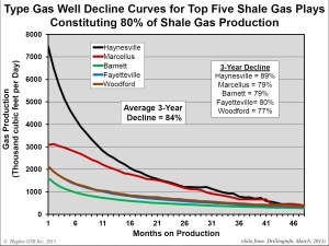
One can only visit a limited area of the Barnett Shal in the space of a day, and of course, it would have been interesting to knock on doors and ask those living there what they think of fracking activities. We concluded that one could not avoid being made aware daily of several fracking sites in the area – the compressors are not silent. I believe that the Parisians will never accept the drilling of 18,000 wells around Paris. Below you can see how rapidly production from a typical well in the Barnett Shale declines. After three years it has reduced by 79%. Tail-end production can continue for 10 to 15 years, but after 20 years it will probably be time to plug the wells and dismantle all the equipment. At that time it may be profitable to be in the metal reclamation business.


It would be interesting to get comments from the readers of this report on my blog “Aleklett’s Energy Mix.” Regarding fracking in Europe, it is mainly in Poland and the southeast of the UK where it is being discussed seriously. For the moment, France has forbidden fracking.
(At the end of this blog I have added images of the Paris Basin.)